|
|
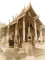
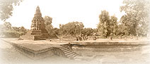
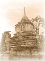
Wat Kan Thom (Wat Chang Kum)
The Viharn of this temple faces to the west and connected
to a Mandapa and house of Buddha image. It is written in the
Yonok Chronicle that King Meng Rai built Wat Kan Thom in 1290.
The Chedi has a base that is 12 meters wide and 18 meters
high. It has double niches which face in each direction. The
lower niche contains and seated Buddha images as the the upper
part enshrines a standing Buddha image. There are also 2 followers
of the Buddha (Mokalana and Saributra) Indra and Nang Torani
or the mother of the earth. In the area of the temple, there
is a Maha Phothi that was taken from Langka in the reign of
King Meng Rai.
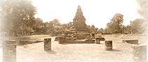
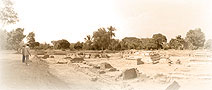
Other important
archeological features are the Hariphuchai Budda tablets and
a red sandstone inscription. Ther are 3 kinds of alphabets
used in the inscription. Mon (1207-1307), Mon-Thai(1277-1317)
and Sukhothai or early Fakam of Lanna (1397).
|
|
 |
|
|
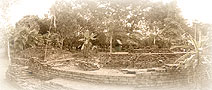
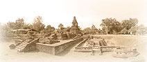
Wiang Kum Kam
The first capital of Lanna
Wiang Kum Kam
was established by King Meng Rai, the King of Yo Nok, as the
first Lanna�s captal. But Wiang Kum Kam had not lasted for
long because the city was facing the problem of severe floods
every year. King Meng Rai had, therefore, founded Chiang Mai
as the new capital where is had better geographic location
than Wiang Kum Kam. But Wiang Kum Kam still maintained its
importance because it was situating as the border town to
Chiang Mai until the end of Meng Rai�s reign.
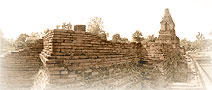
Wiang
Kum Kam capsized because of the severe floods
when it belonged to Burma as a colony (2101-2317 B.C.) and
it was buried under sludge and difficult to revamp. After
that flood disaster, Ping River had changed the direction
of its watercourse. No river channel flew across Wiang Kum
Kam as ever and the entire city was left under sludge for
many hundred year until the name of Wiang Kum Kam faded
away from history and believed that Wiang Kum Kam was only
the town in chronicle.
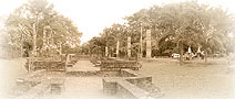
Until the year 2527 B.C.,
when the 4th Section of Silapakorn (Art Department) had
renovated Kan Tom Temple at Chang Kum Temple which was one
of an important ancient remains of Wiang Kum Kam and it
made the story of this legend city became true. From the
study of archaeologists and historians, we can certainly
believe that an ancient remains in the district of Moo 11,
Tambon Ta Wang Tarn, Sarapee District, Southest direction,
5 kilometers away from Chaing Mai is Wiang Kum Kam or the
old capital before becoming Chiang Mai. The sinking of the
city caused by severe flood at the time made Wiang Kum Kam
the underground city before Lanna Kingdom was destroyed,
thus is made an ancient city of Wiang Kum Kam healthy and
was the center to study architecture and arts and also the
pure culture of Lanna which is an important basic to study
Lanna�s culture for the next decades.
|
|